


Beaver Twp. Voting District, Roseau County, Minnesota
About
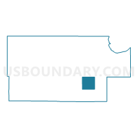
Outline

Summary
| Unique Area Identifier | 604113 |
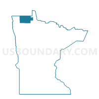
| Name | Beaver Twp. Voting District |
| County | Roseau County |
| State | Minnesota |
| Area (square miles) | 35.63 |
| Land Area (square miles) | 35.41 |
| Water Area (square miles) | 0.22 |
| % of Land Area | 99.39 |
| % of Water Area | 0.61 |
| Latitude of the Internal Point | 48.67215850 |
| Longtitude of the Internal Point | -95.55360800 |
Maps

Graphs
Select a template below for downloading or customizing gragh for Beaver Twp. Voting District, Roseau County, Minnesota


Neighbors
Neighoring Voting District (by Name) Neighboring Voting District on the Map
- America/Beltrami Island Forest Unorg. Voting District, Roseau County, MN
- Falun Twp. Voting District, Roseau County, MN
- Golden Valley Twp. Voting District, Roseau County, MN
- Mickinock Twp. Voting District, Roseau County, MN
- Reine Twp. Voting District, Roseau County, MN
Top 10 Neighboring County Subdivision (by Population) Neighboring County Subdivision on the Map
- Mickinock township, Roseau County, MN (301)
- Falun township, Roseau County, MN (251)
- Southeast Roseau UT, Roseau County, MN (231)
- Golden Valley township, Roseau County, MN (189)
- Beaver township, Roseau County, MN (107)
- Reine township, Roseau County, MN (94)